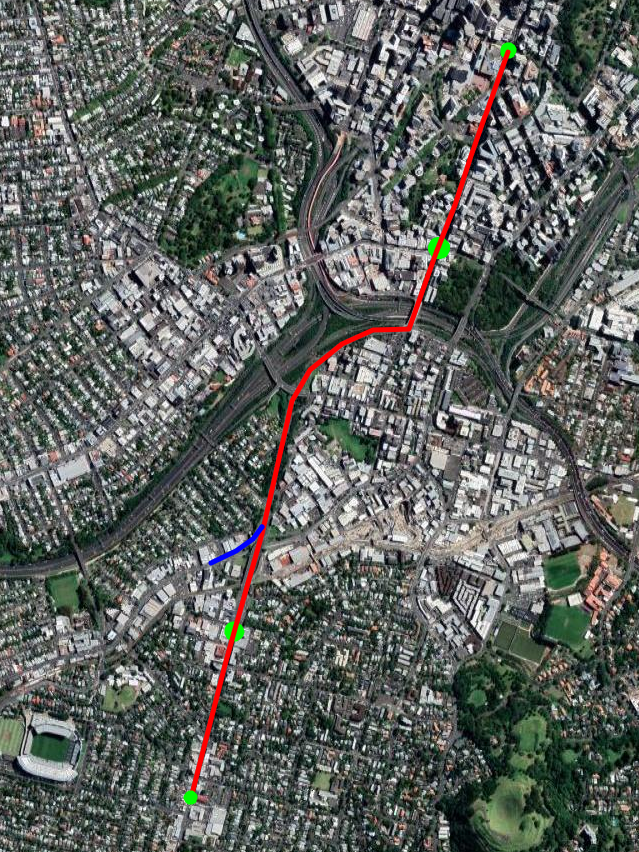
As I covered in my plan for a Metro Line from Takapuna to the Airport getting across Auckland Harbour is difficult. The problem is that while a bridge would be cheaper and have the option of a pedestrian/cycling lane the requirements to allow a 43 metre clearance for ships would require a line too steep for rail to climb
In my plan I ended up going for a tunnel under the harbour as I couldn’t make the bridge option work.
However recently “ifuckinghatethe394” on discord suggested a new option for a bridge. The trick is to run the line parallel to the existing bridge and motorway but have it start climbing much earlier than the motorway does. In the case of the line south of the Bridge it would begin climbing some 500m earlier.
This would means it could reach the required height using a slope that trains, pedestrians and cyclists could easily manage.
Their Concept
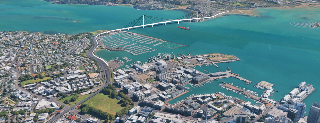
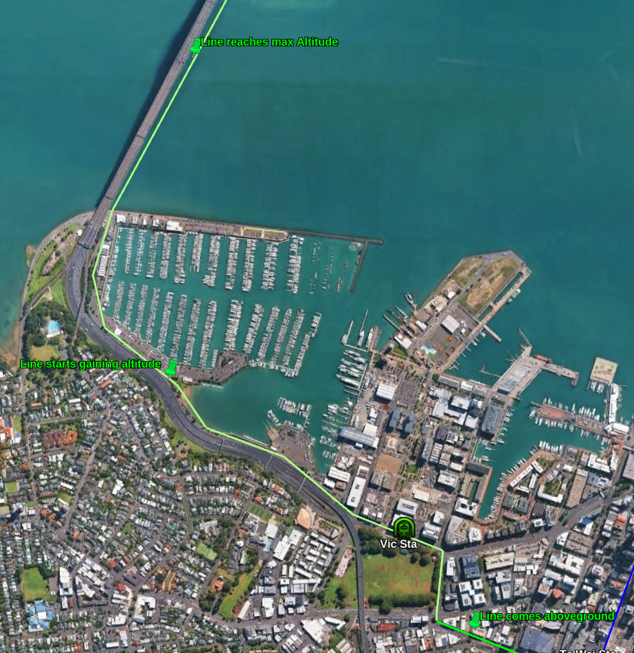
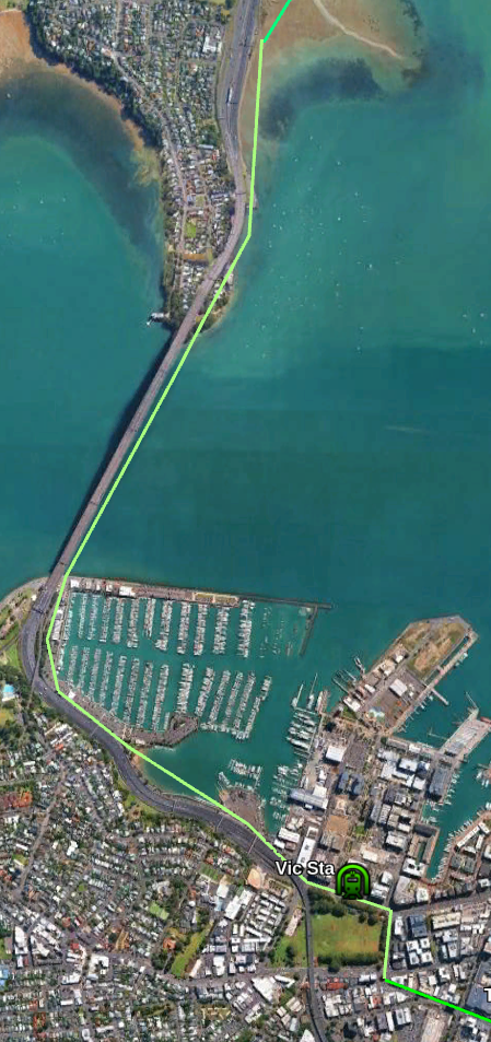
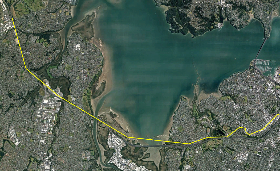
The new line (in white) would start from the south at a line going under Victoria park. It would emerge at the southern end of St Mary’s Bay and climb from there (shown as white) steadily until it became a new bridge just east of the existing bridge. It then decreases height to become an elevated line north of the Harbour.
Review of their idea
The good bit about their idea it uses the extra distance the line is traveling to gain height. Alternative ideas (including my own) have assumed the train gains height in a straight line and then had problems fitting that straight line across Auckland Harbour.
I’m less sure about their route South of the new Bridge. They show the line going underground where there are currently road lines into Fanshawe Street. I have proposed an alternative route below.
My Proposal based on their idea
I would go for a two line light-metro bridge with a 5 metre wide cycling and walking path on the east (water) side. The path could also have slightly wider bits for observation at various point. The light metro would join lines to the North and South as outlined in my previous proposal.
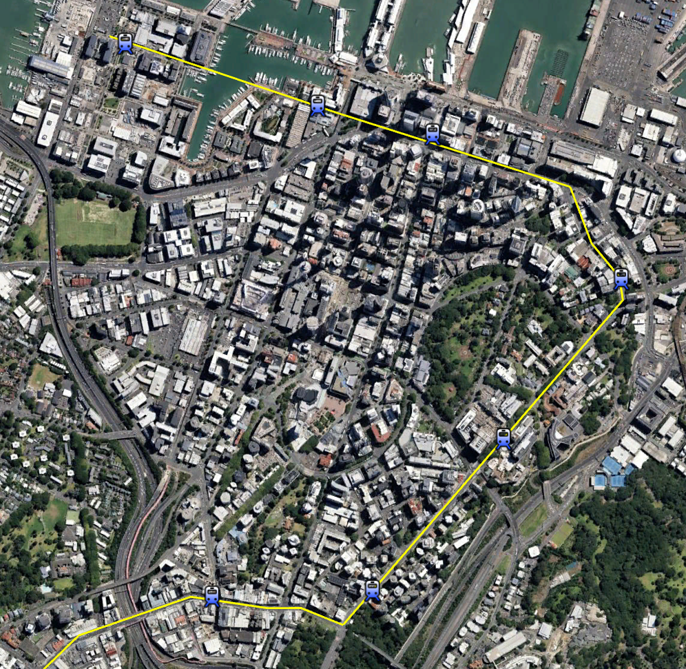
I think that a better option is to have the Light Metro line under central Auckland come out of the ground near the City Works Depot. The line can the go elevated about 10m above the street by the bottom of Wellesley Street West. Then it should turn right into Halsey Street. After going a block down Halsey street it turns left into Fanshawe Street and has a station half way along the block near where the existing bus stop is. Light Metro has a turning radius of around 40-50m so should be room to negotiate these corners.
Ai generated of line turning from Halsey St into Fenshawe St
The line should then switch to the harbour side of the road and follow the motorway along the east (Harbour) side. Around the Westernmost point of St Mary’s bay the cycle/walking path should join the rail-lines and then it should start gaining altitude until it reaches it’s target height (around 46m above sea level) near the middle of the bridge.
The line would climb from 10m to 46m over a distance of 1200m or a 3% gradient. This is well within capabilities of standard metro systems. It is also okay for cyclists and pedestrians.
After going flat for a couple of hundred metres the line would start down agin on the North side of the bridge reach 10m around the police station. The cycling/walking path could then cross the motorway and terminate on Stafford Road while the rail line continues North.
Another option for the path would to have an exit at Stafford road but continue the rest of the path 6km North to Akoranga station (or nearby). This would allow people to cycle all the way from Takapuna to the city.
Comparison to the Tunnel Option
My previous version had a tunnel all the way from the Central city to just off Sulphur Beach. It also had an underground station under Victoria park.
Cost of Underground option from Wellesley St West to Sulphur Beach
3km underground line – $3000m
1 underground station – $250m
Harbour Tunnel extra – $500m
Total – $3,750m
Cost of Elevated Line and Bridge between same points.
4km elevated line – $1200m
1 Elevated station – $25m
Harbour Bridge extra – $500m
Total – $1,725m
So the rough saving is $2 billion. Mainly due to elevated lines being so cheap compared to underground.
Route of undergroundRoute of Bridge option
Conclusion
The new proposed route seems a great idea which fixes the main problem with previous bridge proposals.
Substituting a Bridge for a Tunnel saves substantial amount of money ( $2 billion in my estimate above) and also provides Active Transit options and a possible tourist destination.
Since I posted by idea for two Auckland light Metro lines I’ve had some feedback and made some updates. This is the new version of the article. At the bottom of this article I’m written about the changes and reasoning behind them. You can also read my article on Light Metro Technology to get more information about the technology I am proposing be used.
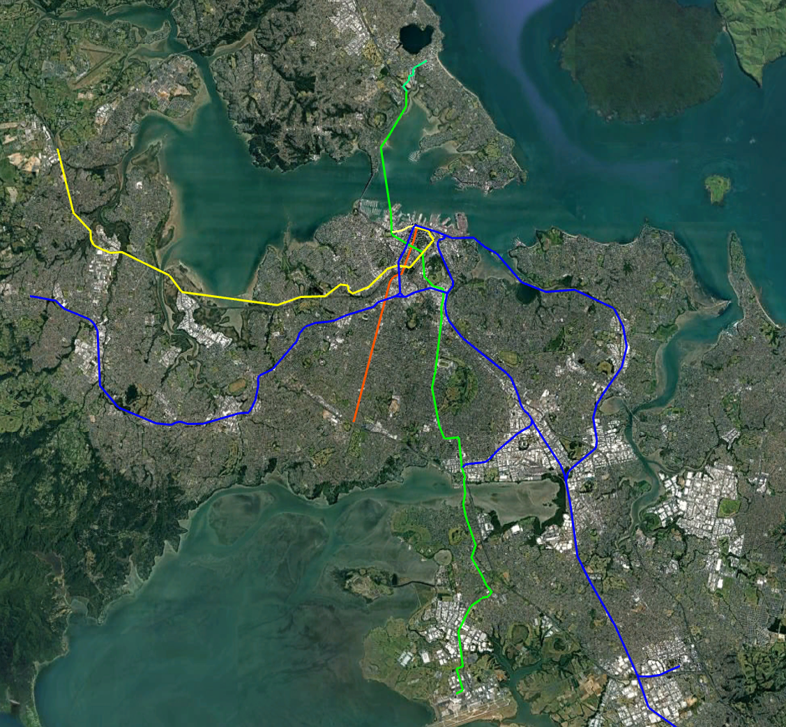
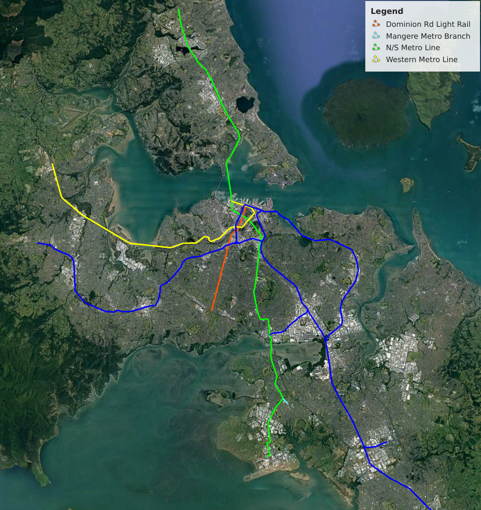
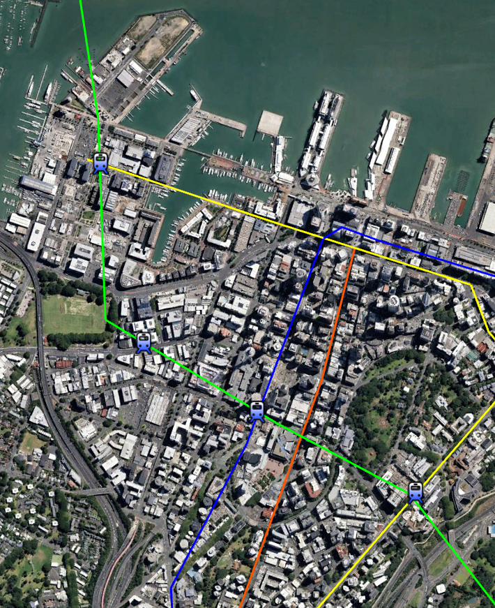
Below is the new network I am planning as a basis for Auckland. It consists of
The existing Heavy Rail network (Dark blue).
A street running light Rail along Queen Street and Domain Rd (Red)
A North/South from the North Shore to the CBD and then the Airport (Green)
A Western line from the CBD to Westgate ( yellow )
In this post I’ll cover the North/South line. Not that all pictures/maps in the article can be opened to see the larger version
Light Metro Technology
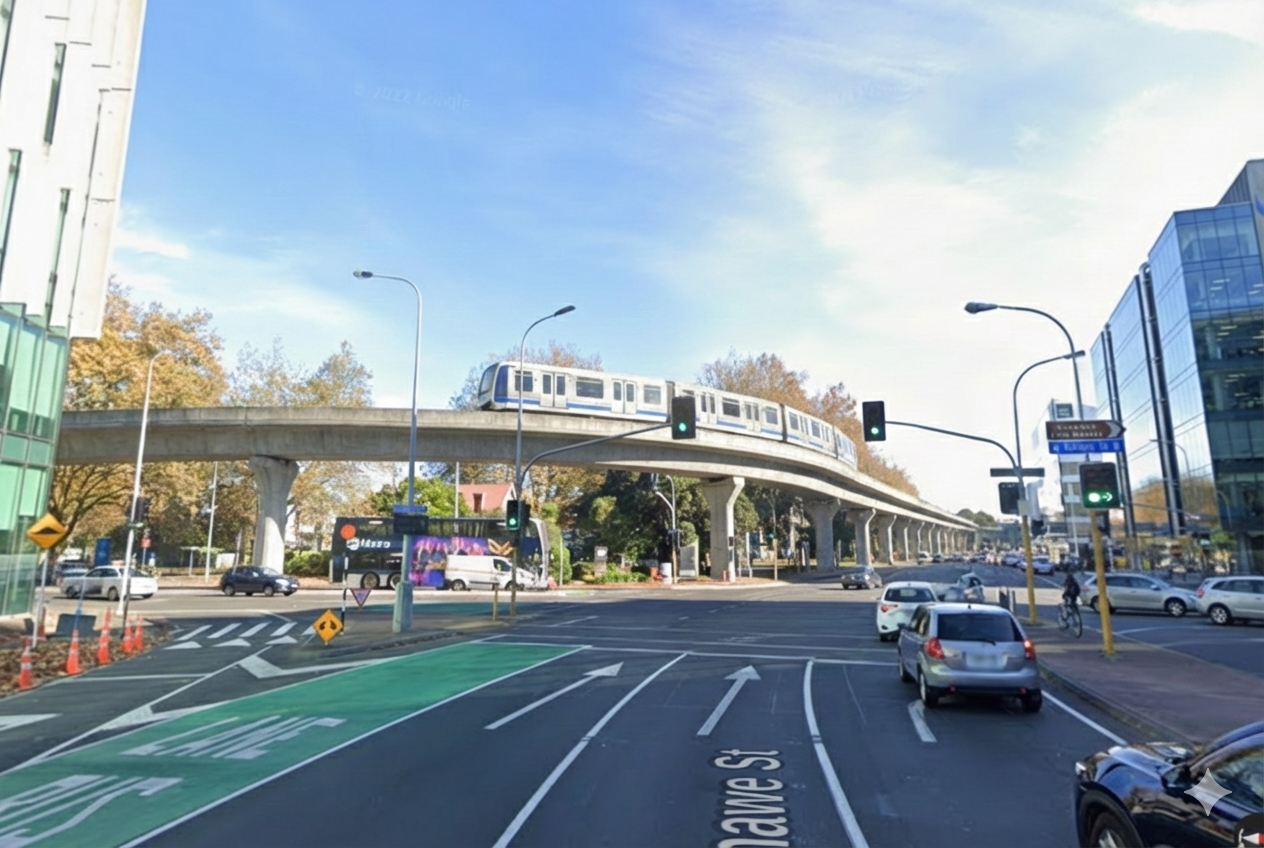
As outlined in a previous article Light Metro is Automated (driverless), Grade Separated with Short Trains and High Frequencies. It is well suited to Auckland where requirements exceed Light Rail but a full metro would be overkill.
The key advantages of Light Metro over street running light rail is it’s high capacity, frequency and higher speed. Attempting to push Light Rail beyond it’s natural sweet-spot result in a grade-separated system that costs as much as Light Metro but is worse and often costs more to run.
The below table shows the capacity of a Light Metro line (in each direction). For Auckland the stations outside the CBD could be serviced by buses to further increase coverage area. Trains could start at short length and frequency increased as high as possible before longer trains should be used.
Headway / Trains per Hour
2 Cars
3 Cars
4 Cars
6 Cars
5 min / 12 tph
2,400
3,600
4,800
7,200
3 min / 20 tph
4,000
6,000
8,000
12,000
2 min / 30 tph
6,000
9,000
12,000
18,000
90 sec / 40 tph
8,000
12,000
16,000
24,000
Max Passengers per hour per direction
If the system is run with 4-car trains ( 52m long, 400 people ) then each line has the capacity over double one of the major Auckland motorways such as the Western or Southern.
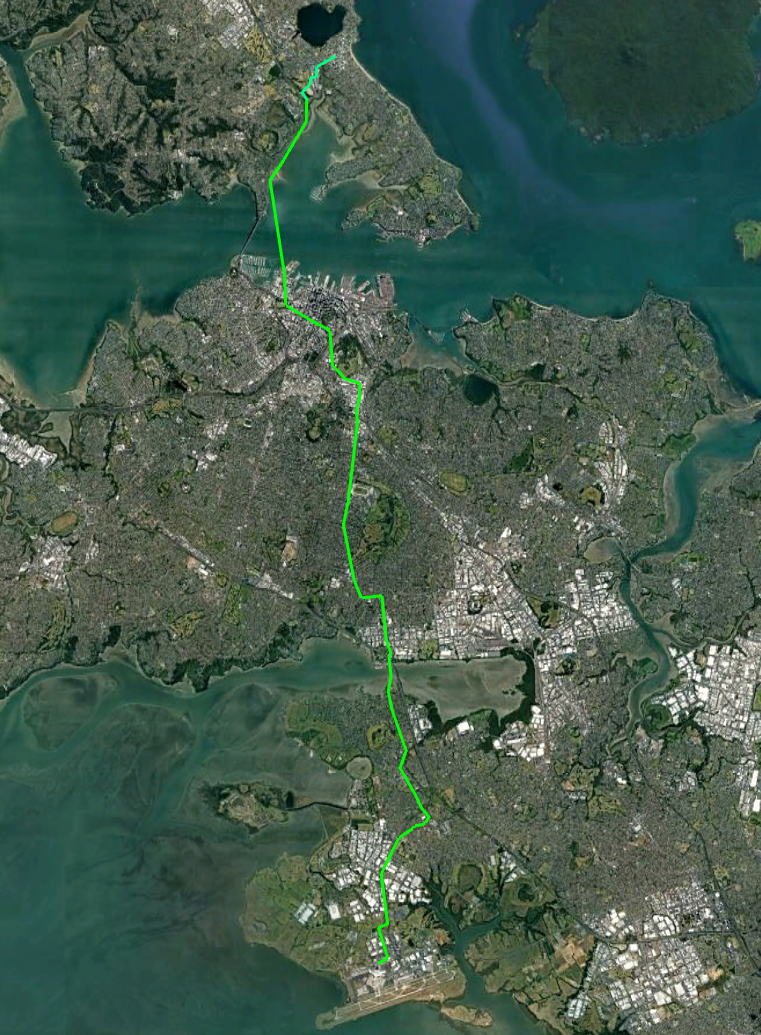
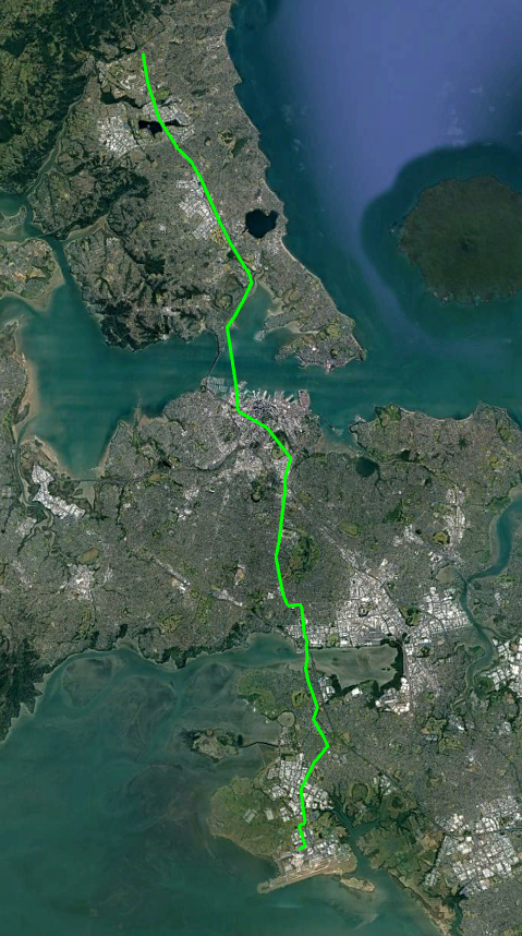
Line 1 – A North/South Metro line from Takapuna to the Airport
This line would start from Takapuna run under the CBD and connect to the Airport in the South.
The line would be grade separated above the road as much as possible since this is cheaper than under-grounding. It would be underground though the central city however.
Total length would be around 28km of which around 6.2km would be underground. Cost would be something like $15b
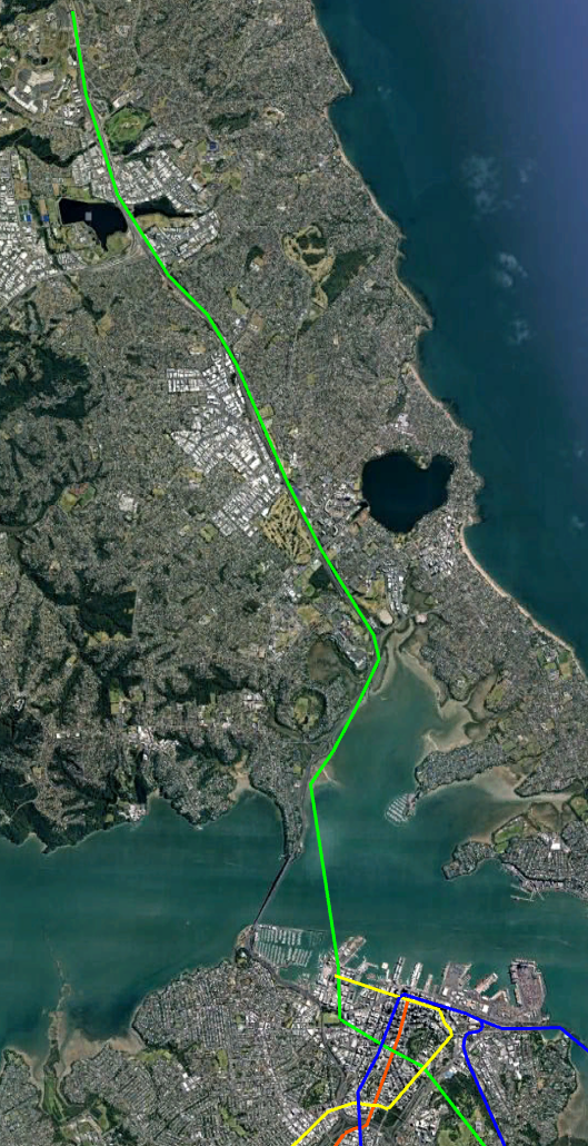
Northern Section
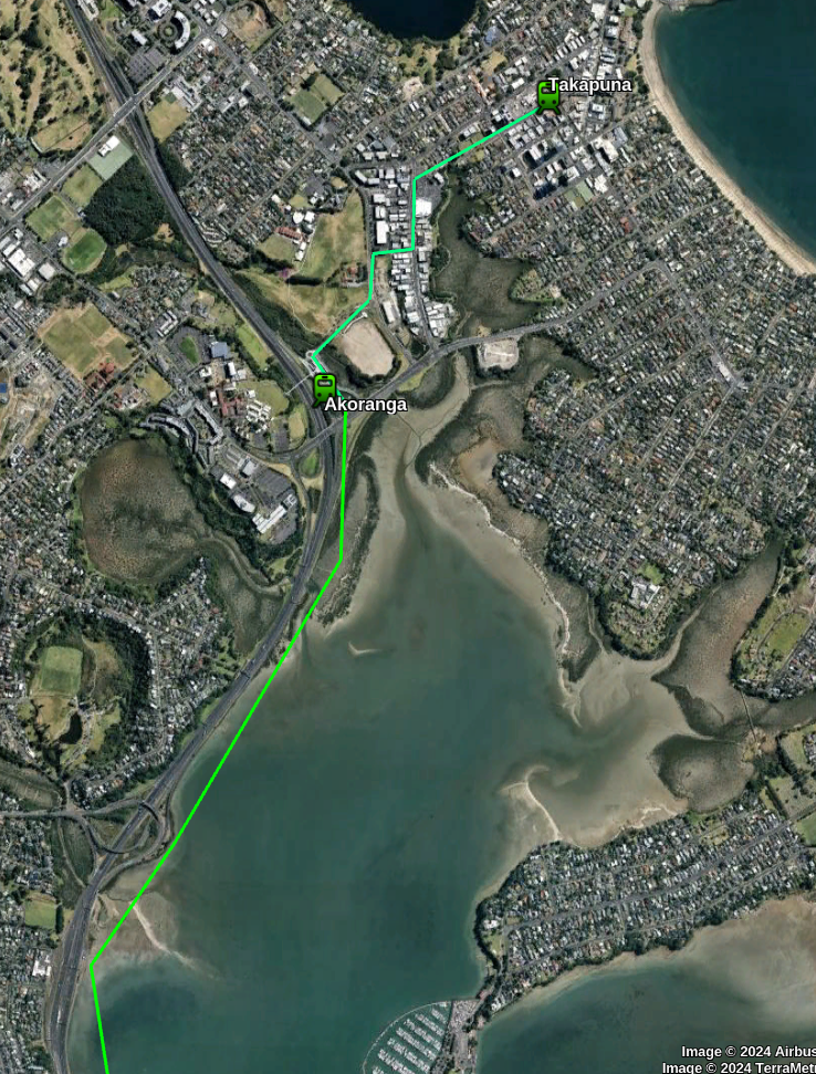
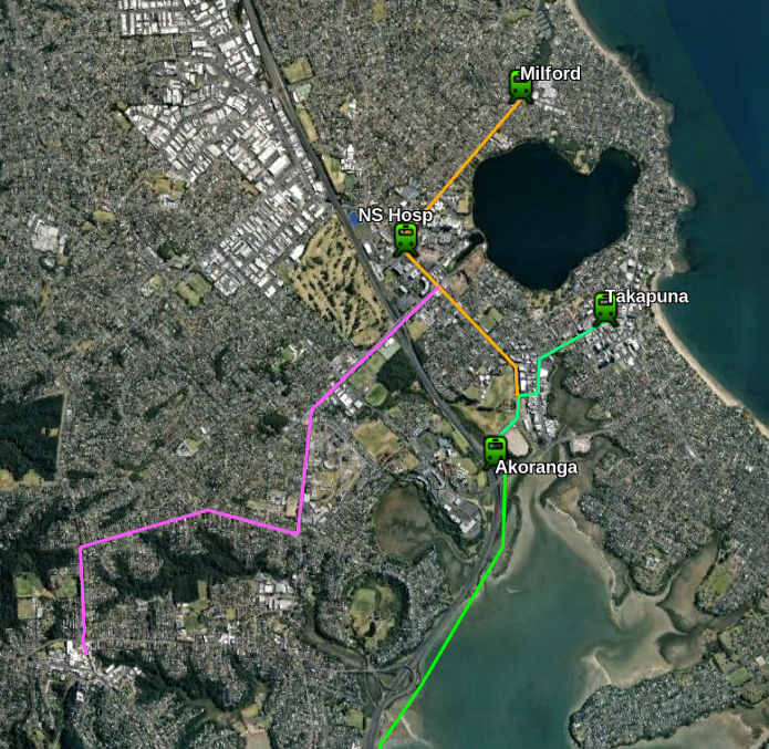
This would be completely overhead and mainly above roadways. It would start from a station at Takapuna and then another station at the Existing Busway station of Akoranga.
The route would then go between the motorway and the sea until it reaches a tunnel across the harbour near Northcote Pt.
See section below for discussion as to the advantages and disadvantages of a tunnel vs a bridge for crossing Waitemata Harbour.
A route to Takapuna avoids duplicating the existing busway. Going off the 2024 bus statistics around 20% of the busway passengers go to Takapuna and Milford and it is likely some more would change from the bus to metro at Akoranga station if the Metro better served the southern part of their journey.
I have mapped out some possible extensions to this line but there are several other options.
A natural extension to this line would be a line to the North Shore Hospital and then Milford.
A line to Northcote and Birkenhead could also be built, although this line unfortunately goes the wrong way for Northcote and Birkenhead people going into the city.
Later lines might go down Wairau Rd to the Wairau Valley
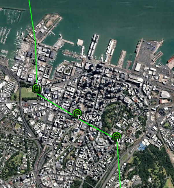
City Section
The first station will be under the eastern end of Victoria Park. Ideally it should have entrances on the far sides of Fenshaw, Halsey and Victora Streets so passengers do not have to cross busy roads to reach it.
The Te Waihorotiu CRL station is apparently already future-proofed with space for a North/South line. The station will effectively be the centre of the Auckland System. There should also be a surface Light Rail line nearby on Queen Street.
The University station would be quite deep (because the line would be under Queen Street and the Grafton Valley Motorway) and probably be an elevator-only station.
I’ll cover how lines intersect later
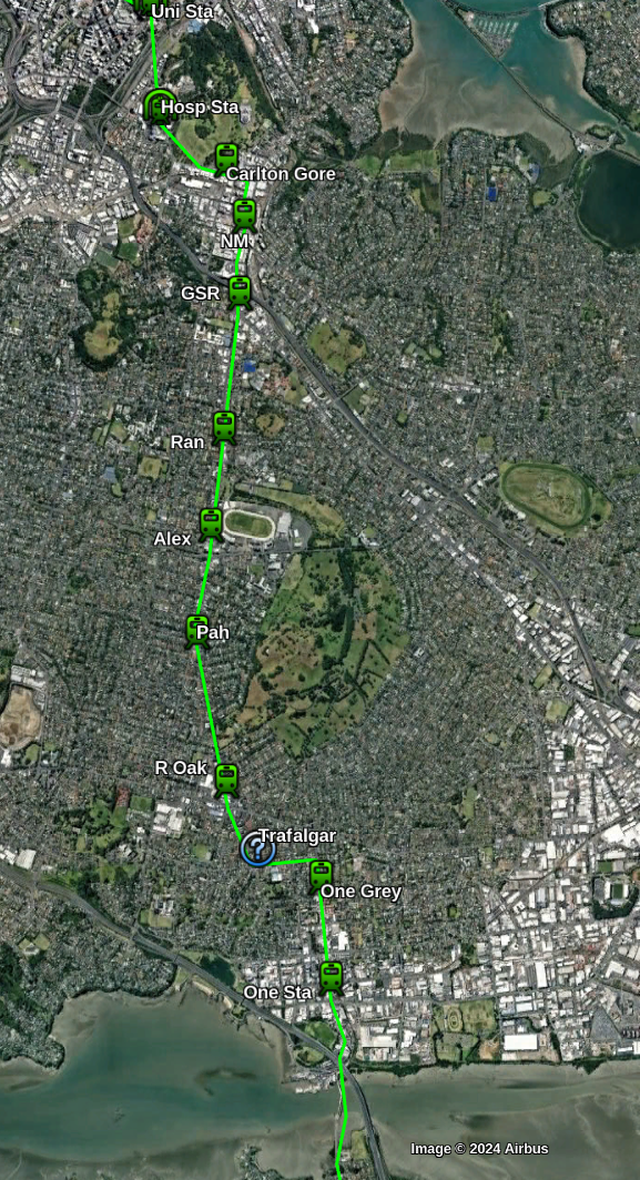
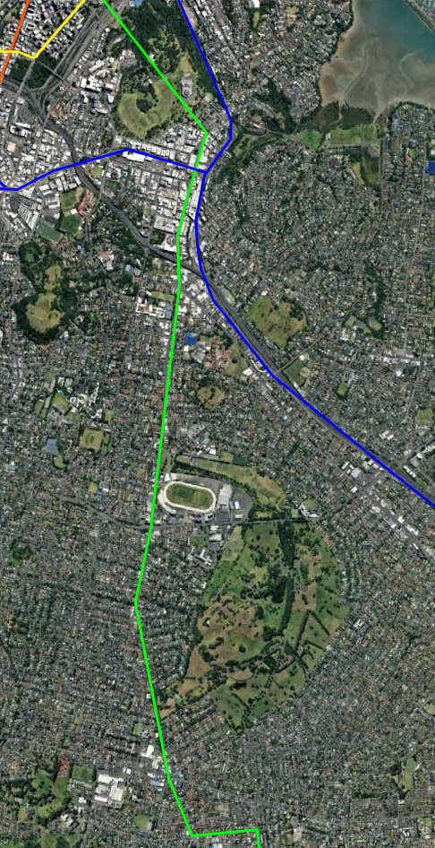
The Southern Isthmus
South of the University the line has a station on the corner of Park Road to serve the Hospital, The Grafton Campus and nearby area. This station may be deep enough to also be elevator-only.
The line comes out of it’s tunnel just after the domain and is now elevated until it reaches the Airport.
The first station is on Carlton Gore road to serve Northern Newmarket. Then there is Station in central Newmarket connected to the existing rail station.
South of Newmarket the line will travel above Manukau Rd and continue South through Royal Oak and Onehunga.
Possible stations could be (at roughly 1km intervals):
Near corner Manukau and Great South Road
Corner of Manukau Rd and Ranfurly Road
Corner of Manukau Rd and Queen Mary Ave (Alexandra Park, Green Lane West Rd)
Corner of Manukau and Pah Roads
Royal Oak Mall
Corner of Manukau Rd and Trafalgar St ( optional / future-proofed )
Onehunga Mall Road near Grey Street
Onehunga Station
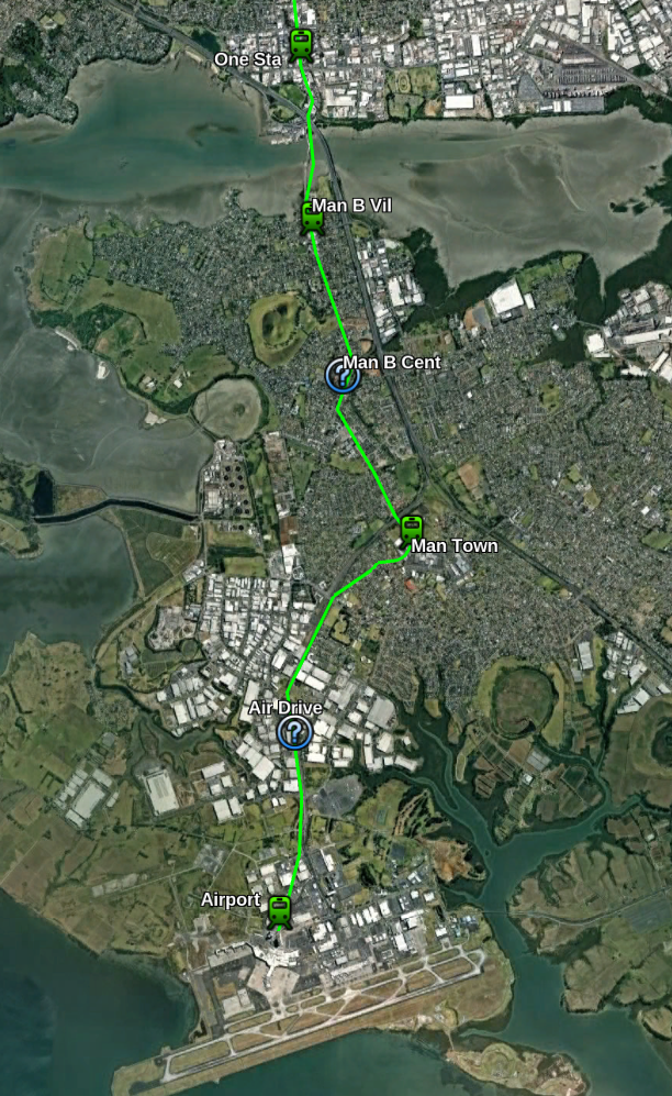
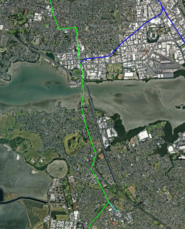
Mangere Section
The southernmost section crosses the Mangere harbour near the current bridges (No special bridge should be needed since it will be fairly low) and has a station at Mangere Bridge Village just South of the crossing.
The line then continues south along the Coronation Rd, McKenzie Rd and Bader Drive with the provision of a future station near Miller Road.
The station follows Bader Drive over the motorway to a station in Mangere town Centre. It then cuts over some houses (which will need to be purchased) back to the motorway and follows it South.
I’ve future proofed a station in the airport industrial area after which the line goes underground between Landing Drive and Ihumatoa Road for about 1km to a station under the airport.
The Depot for the Line would probably be best placed somewhere between the Airport and Mangere Town Center Station.
Bridge vs Tunnel for the Waitemata Harbour crossing
The plan currently has the line using a tunnel. This is probably about $1b more expensive than a bridge and makes it very difficult to provide a walking or cycling option.
The reason for this is that currently the Upper Harbour (West of the Auckland Harbour Bridge) has Chelsea Sugar Refinery and the Kauri Point Armament Depot. Both of these much be reachable by large ships. This requires a clearance of any bridge over the water to be similar to the current bridge’s 43 metres.
Since trains have problems with gradients much over 3% this would require over 1km of climb to reach which is almost impossible to fit south of the ship channel.
If the Sugar Refinery and Ammunition Depot can be moved then a lower bridge quickly becomes the best option. With a saving of over $1b it might be better to pay for them to move. However I have kept things as a tunnel for now.
CBD stations and line intersections
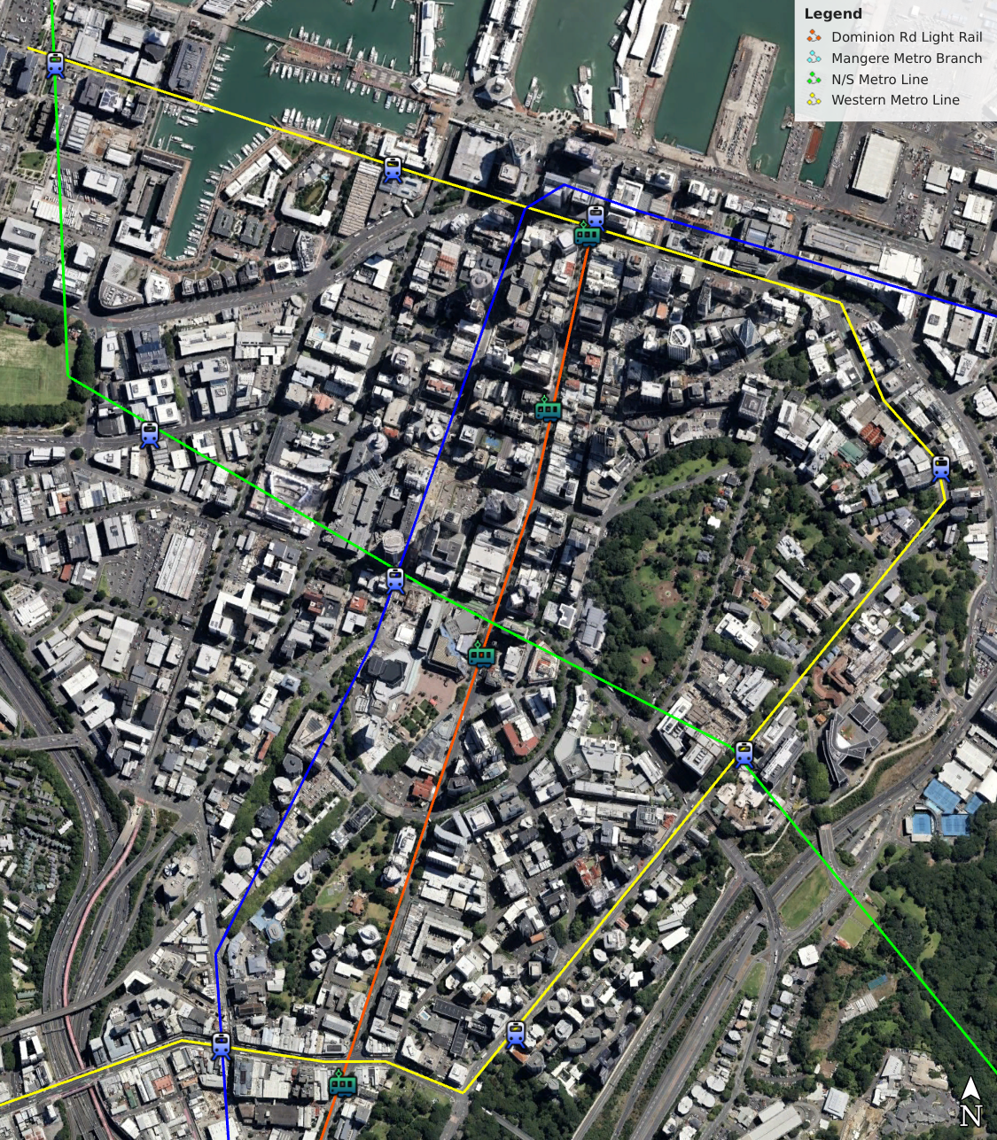
This maps shows the other lines including the existing lines, a Queen St Light Rail and my proposed Western line.
The Victoria Park station as well as serving the immediate area supports transfers to the Western Line to get to lower-Queen Street and transfer to College Hill and Northcote buses
The Te Waihorotiu Station allows access to Aotea Square area and transfers to the CRL and Light Rail
The University Station serves the Universities and allows transfers to the Western line and Symonds Street Buses.
Southern Branches and Other Lines
As the lines gets further South the demand on the single line will be reduced. So I propose that the line eventually branch just South of Newmarket
The new line would go down Great South Road as far as the existing Penrose Station and then East along Penrose Rd to meet the Sylvia Park station. It would then go East to Pakuranga and down Ti Rakau Dr to Botany. The existing Greenlane and Remuera stations could perhaps be replaced by Stations on the line
Because Light Metro can handle very high frequency, capacity on both branches would be high. For example trains could be every 2 minutes in the central areas and every 4 minutes on the branches
I’ve sketched out some later lines mainly to make sure the planned line has room for growth.
The first is a line from Mangere Town Center to Botany that goes though Papatoetoe and Otara.
The other is a cross town line that Starts in Point Chevalier and Follows Carrington, Mt Albert, Mt Smart and Great South Roads to Manakau City.
Penrose station would be a natural intersection point for two of the lines (and the existing heavy rail) and could be upgraded to be a major transfer station.
Keeping the cost down
It is important to keep the cost of the line down as much as possible to improve it’s chances of being built. Especially the urge must be avoid to create expensive monumental stations or under-grounding more sections to avoid perceived disruption.
I propose the following measures
Elevated Line instead of Underground where possible.
A standard simple design for elevated stations. Cheap colour and art can provide differentiation for a small percentage of the cost
Simple underground stations
Leaving space for some stations to be built later
Relatively small elevated stations. Perhaps only with 60m (4 car) platforms being initially built but space left for larger additions later.
Driverless operation
Using Standard off-the-shelf Train systems that are already deployed elsewhere with minimal changes
Note that driverless operation allows frequent trains which in turn allow shorter trains which means smaller cheaper stations.
Costing
I put my costs are what I consider realistic New Zealand levels. Some countries are able to build for less but I’ve listed what I hope New Zealand can build for.
$1b/km underground lines
$300m/km for elevated
Stations: $25m elevated, $250m underground
$1b/km + $500m extra for Harbour Tunnel
North/South Line length by type of track
4.1 km Overhead from Takapuna to the Tunnel
A 2.4 km tunnel across the Harbour
A 3.7 km tunnel under the CBD
8.6 km to the northern shore of Mangere Inlet
7.7 km overhead across the inlet and South
1 km underground near the airport
Total
4.7 km underground
2.4 km Harbour tunnel
20.4 km overhead
Total cost
4.7 km underground at $1b/ km = $4.7b
2.4 km Harbour Tunnel = $2.9b
20.4 km of overhead line at $300m/km = $6.1b
13 overhead stations at $25m each = $325m
5 underground stations at $250m each = $1250
Total = 15.2b
General observations and conclusions
Travel times for this sort of Metro are around 30km/h including stops although this line has fewer stops than most and some long stretches so should be a bit faster. Assuming 30km/h we get:
Airport to Te Waihorotiu station 19.4km = 38 minutes
Takapuna to Te Waihorotiu station 8.1km = 16 minutes
Currently the Airport takes around 1h 30m via public transport and 40 minutes for the Skydrive private Airport bus outside of peak times. The bus from Takapuna takes 20-25 minutes. Remember that the metro will have very high fequency so waiting for the next train will only be a couple of minutes.
I’ve tried to make the route realistic and useful. As far as I can tell all the climbs are within the capacity of a typical metro system. However some of the corners may be a little tight and additional space may be needed.
While only a small proportion of the passengers will travel to and from the airport I think the service will be great for this. Some people do express concern about room for luggage but riders manage on other systems around the world.
I think that this line and the Western line has a great potential to improve transport across Auckland. It will take pressure off the Northern Busway and also add huge capacity to the South West and Airport.
My next article will cover my proposal for a Western Line
Changes since previous version
General
I’ve made 3 stations on the line optional to save cost and increase speed
North Shore
Instead of replacing the Northern busway I’ve updated the line to go to Takapuna and eventually Milford instead. This will be around 1.7km from Akoranga Station rather than 10km so it should say $2-3 billion from the initial build and mean that we augment the Northern Busway rather than replace it..
I’ve included a few possible routes but there are a lot of options both for the initial route into Takapuna and future lines.
Central City
I’ve replace the Wynyard and Victoria stations with a single station under the east of Victoria Park. It would also have a similar service area to the two stations.
I’ve also rerouted the end of the Western Line to go along Fenshaw St rather than across the Viaduct Basin
Auckland Hospital
My original plan had the line going South from the University, under the motorway and Museum and emerging on the North of Newmarket
However skipping the hospital seems a bad idea. It is a huge trip generator not just for the hospital but for the Grafton Campus and other businesses and housing nearby.
So I’ve updated the route to have a station under the corner of Park road and the line emerging on Carlton Gore road with a station near the bottom of that road.
Mangere
I’ve changed Mangere town centre to be directly on the line instead of a short branch. This does mean the line goes through housing to get back on the motorway.
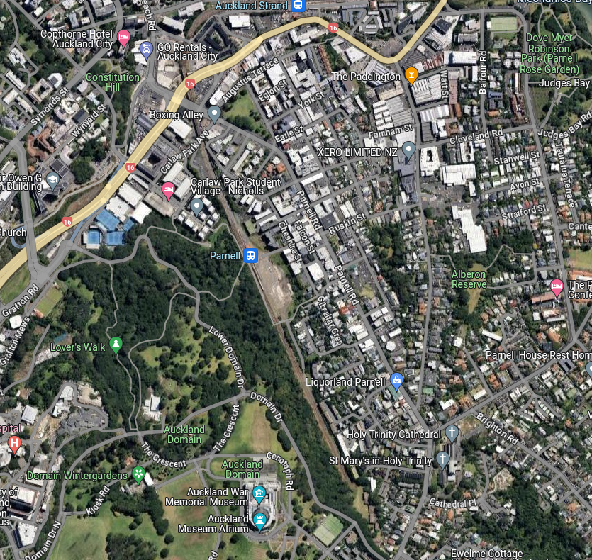
Since it opened in 2017 Parnell Station has been one of the least busy stations in Auckland. In the year to June 2019 there were just 168,000 boardings at the Station, ranking 36th out of 40 stations on the network.
While the suburb of Parnell is fairly high density and has a good mixture of retail, entertainment, office and residential is it under-served by the station.
Parnell Station’s main problem is that it is in a valley with the Auckland Domain on one side and a steep hill to Parnell Road on the other. The way up the hill is steep, indirect and is not suitable for people with mobility issues. The route to the museum is a rough walking track. There is a dedicated path to the Carlaw Park student village and business centre however.
The poor accessibility to the main Parnell Road shopping/business area and even worse access to the St Georges Bay Road business area have hurt the station’s usage. These problems have been written about previously on Greater Auckland, twice.
A wheelchair accessible underpass between the two platforms was added to the station in early 2024. This enabled safer and easier transfer between platforms and to access to the boardwalk to Carlaw Park. However the hill to Parnell Road is still a problem.
A Possible Solution – A Pedestrian Tunnel
My proposal is a pedestrian tunnel running from near the Parnell Station to the North-West under the main hill and emerging on St Georges Bay Road. Around the middle of the tunnel there would be elevators going up to Parnell Road. The tunnel would be around 550 metres long. The ends are at similar heights so the tunnel would be relatively flat while the central elevators would need to travel around 20 metres. The tunnel should be wide, well-lit and have security cameras etc to make people using it feel safe.
The elevators would be around 3 minutes walk from Parnell Station on 4-5 minutes from St Georges Bay Road. I’ve place the street level access to the elevators in Heard Park on the corner of Parnell Road and Ruskin Street (at the bend in the above map). Probably several elevators would be required for redundancy and since traffic will probably be bursty.
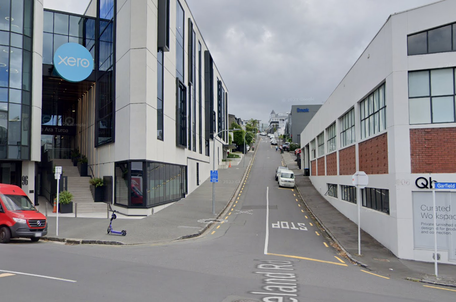
The St Georges Bay Road entrance could be at the bottom of Garfield Street. It would probably be easiest to take up some street/footpath space and run parallel to the road before turning South-West once significantly deep. There are several hundred jobs within a couple of minutes walk of this entrance. There is also a Saturday Market nearby.
Overall the project should be only moderately expensive to build and improve the catchment and value of Parnell Station as well as linking three parts of Parnell better together.
In my previous article I covered why Light Metro is the best technology of the next major stage of Auckland’s train network. Here I present a couple of lines that could be the basis for a future network.
The lines are designed to form a mesh an enable transfers (especially in the CBD) but are of course just ideas. One problem I have encountered is steep sections of track, these will require the track to smooth our the height differences and for trains able to handle climbs of around 5%.
I am estimating costs as $300m/km for elevated sections and $1b/km for underground sections. Hence I have used elevated line wherever possible.
As outlined in my previous article Light Metro is Automated, Grade Separated with Short Trains and High Frequencies. It is well suited to Auckland where requirements exceed Light Rail but a full metro would be overkill.
The key advantages of Light Metro over street running light rail is it’s high capacity, frequency and higher speed. Attempting to push Light Rail beyond it’s natural sweet-spot result in a grade-separated system that costs as much as Light Metro but is worse and often costs more to run.
The below table shows the capacity of a Light Metro line (in each direction). For Auckland the stations outside the CBD could be serviced by buses to further increase coverage area. Trains could start at short length and frequency increased as high as possible before longer trains should be used.
Headway / Trains per Hour
2 Cars
3 Cars
4 Cars
6 Cars
5 min / 12 tph
2,400
3,600
4,800
7,200
3 min / 20 tph
4,000
6,000
8,000
12,000
2 min / 30 tph
6,000
9,000
12,000
18,000
90 sec / 40 tph
8,000
12,000
16,000
24,000
Max Passengers per hour per direction
If the system is run with 4-car trains then each has the capacity over double one of the major Auckland motorways such as the Western or Southern.
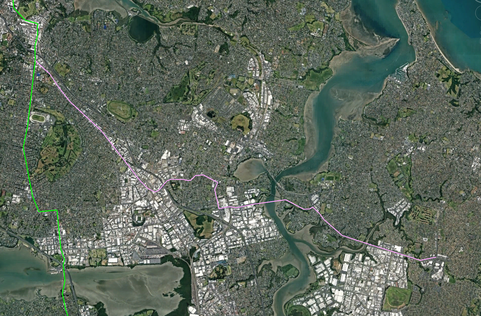
Line 1 – A North/South Metro Line from Albany to the Airport
This line would upgrade the Northern Busway on the North Shore, run under the CBD and connect to the Airport in the South.
The line would be grade separated above the road as much as possible since this is cheaper than under-grounding. It would be underground though the central city however.
Total length would be around 36km of which around 5.5 would be underground. Cost would be something like $15b
Northern Section
This would start at the exiting Albany bus centre and follow the Northern busway to Akoranga station. It would then go along the shore until roughly opposite Sulphur point where it would either go in a tunnel or bridge over the Harbour to Wynyard Quarter. Stations would be Albany, Rosedale, Constellation, Sunnynook, Smales Farm, Akoranga
The Northern Busway should be kept South of Akoranga Station for use by buses from Takapuna, Northcote and Brikenhead. This would give the system more capacity and is easier than those people transferring from a bus to a train for such a short ride.
Travel time from Albany to the Te Waihorotiu Station (Aotea) should hopefully be around 25 minutes.
City Section
Once over the Harbour the line should head underground and have a series of stops in the Central City. I would suggest
Central Wynyard Quarter near Madden St
Near Les Mills on Victoria St West
Te Waihorotiu Station (Aotea)
University / Symonds St
The Te Waihorotiu CRL station is apparently already future-proofed with space for a North/South line. The station will effectively be the centre of the Auckland System. There should also be a surface Light Rail line nearby on Queen Street.
The University station would be quite deep and probably be a an elevator-only station.
Southern Section
South of Grafton Valley the line would go under the domain before going through Newmarket. The line could either be above or below ground though Newmarket but will be above ground once it reach Manukau Road.
Update: Feedback has convinced me the line should have a stop under Park Road near the Hospital and another at the bottom of Carton Gore Rd.
I don’t think having a station for the Museum is justified but there could also be a station at the North of Newmarket near Sarawia St. There should be at least one station in Central Newmarket near the existing Train station to allow transfers
South of Newmarket the line will travel above Manukau Rd and continue South through Onehunga and Mangere Bridge.
Possible stations could be (at roughly 1km intervals):
Near corner Manukau and Great South Road
Corner of Manukau Rd and Ranfurly Road
Corner of Manukau Rd and Queen Mary Ave (Alexandra Park, Green Lane West Rd)
Corner of Manukau and Pah Roads
Royal Oak Mall
Corner of Manukau Rd and Trafalgar St
Onehunga Mall Road near Grey Street
Onehunga Station
Mangere Bridge Village
Corner of McKenzie and Millar Rd
Corner of Bader Dr and Idlewild Ave
Mangere Town Centre (see below)
Airport Drive Area
Airport Terminal
The Southern Section would have roughly 16 stations and take over 18km and would take around 30 minutes to cover from the Airport to Te Waihorotiu/Aoetea Station.
Previous proposals have followed the motorway but I’ve switched this to following roads inside the suburb of Mangere Bridge and giving the suburb 3 stations with the Millar Rd one having good connectivity to Favona.
The Mangere Town Centre station would be a branch off the Bader Drive station. It could be run as a shuttle. Eventually the line could be extended East along Buckland Road to Papatoetoe Station then North to Otara and/or South to Manukau
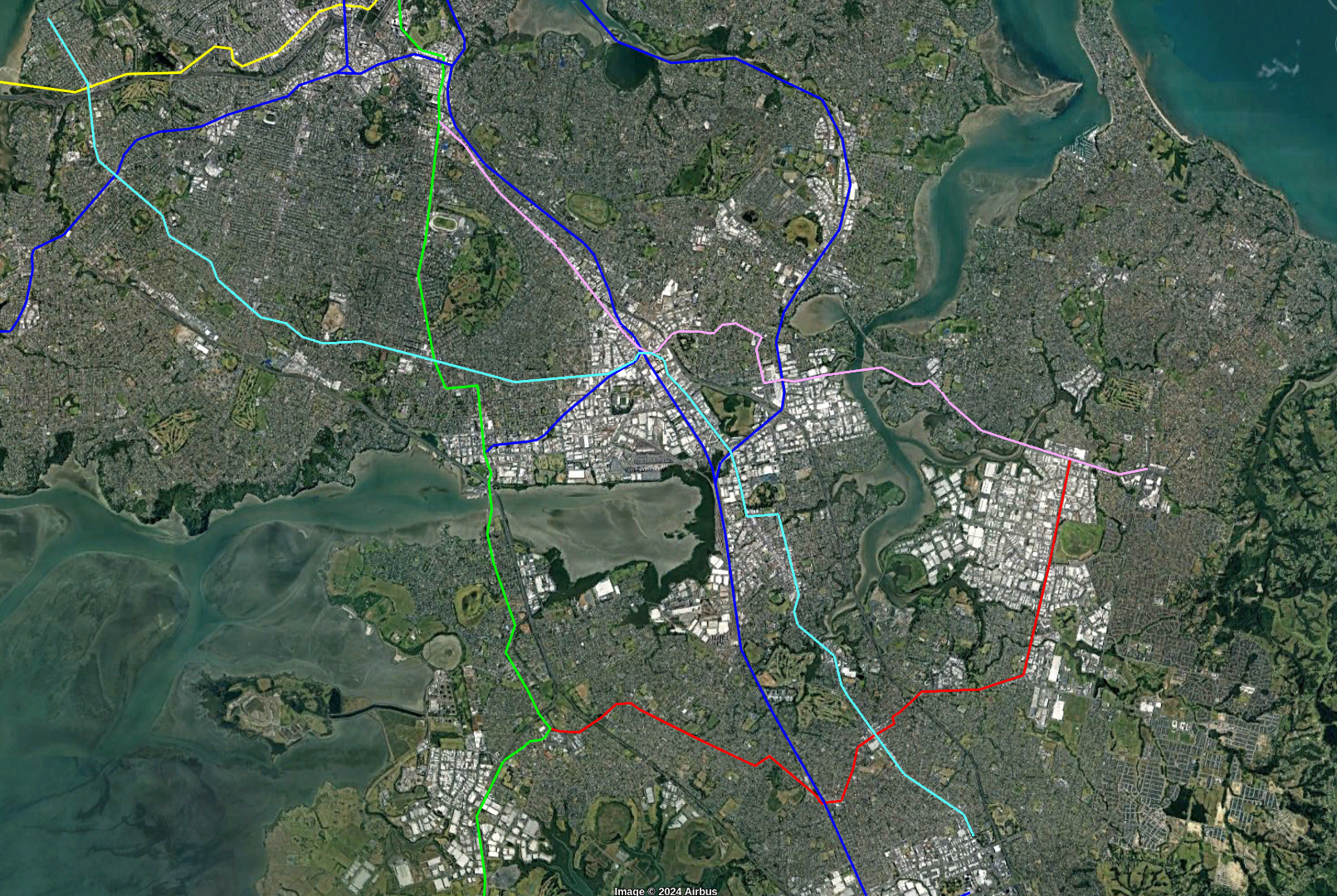
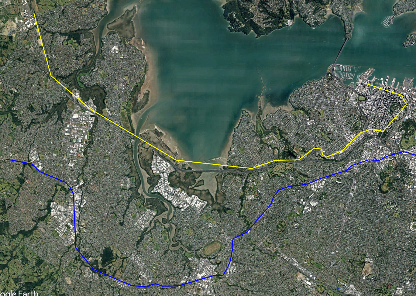
Line 2: North-West Metro Line from Westgate to the City
New line in yellow, existing rail line in blue
This line is intended to fill the gaps to the North of the existing Western Rail Line and use the Motorway corridor. Closer to town it will go above Great South Rd and Karangahape Rd.
It will then do an above-ground spiral around the city to improve coverage and transfers.
Total length would be around 20km and all above ground. Cost would be something like $6b
Western Section
This would run from Westgate to Karangahape Road mainly along the North Western Motorway and Great North Road (GNR). It would be roughly 16km long and 100% overhead.
Stops could be: Westgate Shopping Centre, Royal Road, Huruhuru Road, Lincoln Road, Te Atatu Road, Rosebank, Point Chevalier Shops, Zoo / MOTAT, Corner GNR & Bond St, Corner GNR & Williamson Ave, Corner GNR and Newton Rd, St Kevins Arcade.
City Section
The St Kevins Arcade stop on Karangahape Rd should be designed to allow people to easily transfer to either the Dominion Rd Light rail on Queen St or the Karanga-a-Hape CRL station.
After the St Kevins Arcade stop the line continues east along Karangahape Rd and then turns down Symonds Street, Anzac Ave, Customs Street and then across the Viaduct Basin to Madden street.
St Kevins Arcade
Symonds St near City Rd
Symonds St near the Engineering School
Symond St near Parliament St
Customs St near Britomart
Customs St West near Market lane
Madden St near Daldy St
The line has seven stations in the CBD and intersects all the other lines twice. This enhances the coverage of the other lines via transfers. Extra stations are also a lot easier and cheaper to build on this line than the underground lines.
eg Someone coming from the North Shore on the N/S Metro could get off at Wynyard Station and Transfer to the Western Metro Line. They would then only have to wait a couple of minutes to catch a train to the Britomart station.
Dominion Road Light Rail
This has been covered elsewhere in detail but building a Lower Queen St to SH20 surface Light rail line fills a gap in coverage and provides additional capacity along Queen Street fairly cheaply.
The line would be mostly separate from car traffic on dedicated lanes in the Center of Dominion Rd and Queen Street. Length would be 8km.
Followups Lines
The above two lines probably give Central Auckland significant metro coverage to last many years. Future lines in Ponsonby, Sandringham, Mt Eden, The CDB, and Newmarket would probably be best served by cheaper street running light rail.
Further out Light Metro may suit the longer distances. Lines or Branches like:
Te Atatu
Point Chev to Onehunga
Mangere to Papatoetoe
Papatoetoe to Otara and then on to Botany
Manukau to Papatotoe, Howick and Manurewa
Takapuna
Orewa
Areas like Remuera could use either technology or just retain bus-based feeders
Questions
Q: Why not Light Rail?
A: Street running light rail is suitable for many sections but it lacks the higher capacity and speed of Light Metro. This is need for long busy routes like the link to the North Shore. If you Grade Separate the Light Rail then you end up spending as much as Light Metro for an inferior product.
However Light Rail is suitable for many routes that don’t justify the extra speed/capacity. This includes Dominion Road and additional filler routes around the CBD that need a step-up from buses.
Q: Why not Heavy Rail?
A: A System compatible with New Zealand’s current service would not work. It would not be able to handle turns, climbs and automated operation without extremely expensive changes which would lose all compatibility. The existing routes (including the CRL) are already full so no savings via reuse is gained.
Q: Why elevated instead of tunneled?
A: Because it is cheaper. Cost for tunneled is usually at least twice that of overhead and can often be more. Yes, not everybody likes the look of overhead lines but going underground can increase the cost by enough to derail the project.
Q: What about steep sections?
A: Certain section of the lines are quite steep due to Auckland’s terrain. This may cause a problem with the route. Light Metro can handle steep slopes than Heavy Rail but handling it may require additional measure like altering the height of lines so they smooth out slopes.
As of 2024 the Auckland Light Rail proposal has died. What started as a cheap surface light rail running down the centre of roads became a largely underground system and the cost spiral to at least $15 billion.
In this post I will outline why I think that medium-distance high-traffic routes should instead be built using Automated Light Metro technology.
In a followup post I will suggest a possible 2 line backbone for Auckland. Combining Light Metro with the existing heavy-rail system, some street-running light rail and buses this could be a system which could be built for less than the cost of the governments light-rail proposals and leave lots of room to be extended
Much as motorway project are planned years in advance this could be something that is largely designed and ready to be built when funding and political will are both available.
What is Automated Light Metro?
Automated Light Metro is what Wikipedia classifies as a Medium-capacity rail system , it has greater capacity than light rail but less than a Full Metro System.
For this article will be based the Hitachi Rail Italy Driverless Metro but there are similar systems from other vendors. The Hitachi Rail Italy Driverless Metro system is deployed in several metros including Copenhagen, Brescia, Milan and Taipei.
The main characteristics of the system are:
Automated (Driverless) Operation
Grade Separated – Mainly overhead
Short trains ( 30 – 100m )
Trains up to every few minutes (or less).
Large capacity of passengers per hour
Platform Screen Doors
Off the shelf Solution
Automated Operation
An important part of the system is that the trains are driverless. Only around 4 people in a control room are needed to run a whole system (which could be 100 trains). Automated operation allows trains to be scheduled close together and also makes it cheap to run lots of trains even off-peak. A train every 10 minutes at 1am for instance.
Grade Separation – Overhead vs Underground
Grade Separation means that there are no crossings of the track. It either runs underground or overhead. This means the track can’t be blocked and is basically required for automated operation.
I’m advocating that lines should be overhead whenever possible. The main advantage of this is lower cost (a third to a half of underground), speed of construction and in some cases easier access to stations.
While some people don’t like the look of overhead lines these will be running on existing motorway or road corridors. Spending billions to put the lines underground is a waste of money that can be used to build more tracks (or result in nothing being constructed at all due to cost)
I think people who worry about the look of overhead rail forget how ugly 4-5 lanes of car-filled roads really are. Not to mention the noise and fumes.
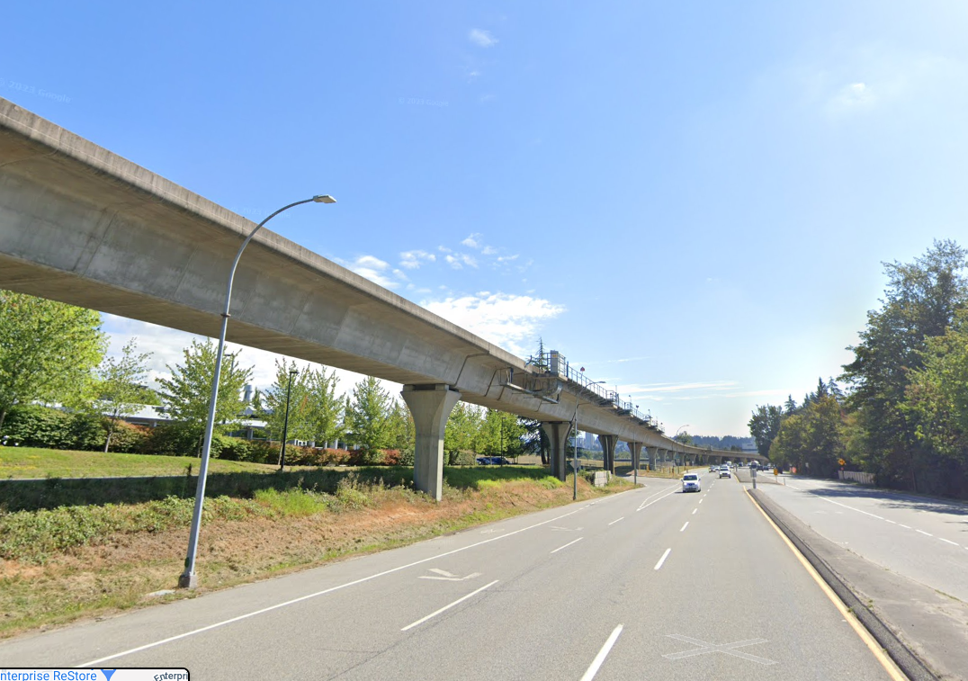
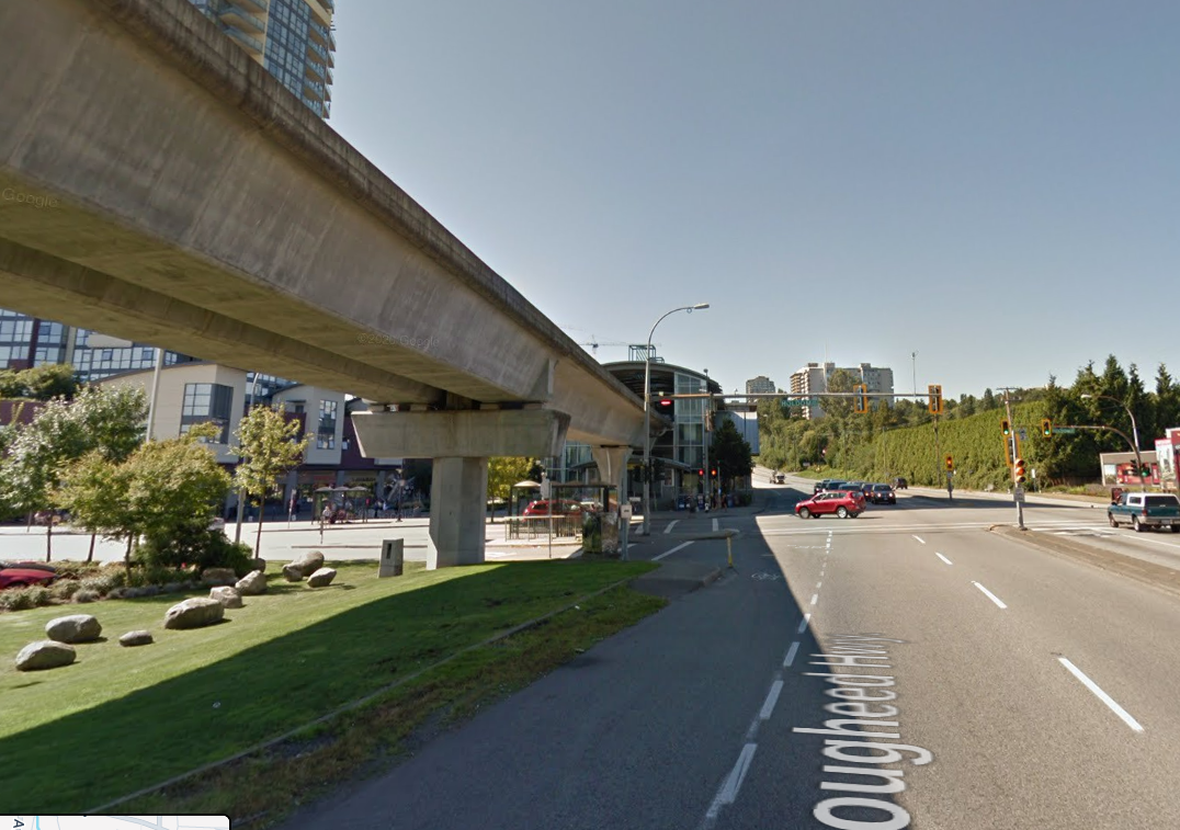
Compare these shots of the Vancouver Skytrain running alongside roads.
Some underground track will probably be required for the CBD but in light of the high extra cost it should be minimised.
Short Trains
Compared to the existing Auckland trains the Light Metro cars are around half the length. This means a 4-car Light Metro train is around 52m vs 145m for a 6 car NZ AM Class train. However the denser loading and greater frequency means that the capacity is around the same.
The shorter Light Metro trains allow for smaller and cheaper stations. Platforms can be smaller and lifts and stairs can be sized for smaller “waves” of passengers.
Very Frequent Trains
Automated Light Metro Systems can have very short intervals (headway) between trains. 90 seconds is available off-the-shelf which allows 40 trains/hour in each direction. This means that passengers are not sitting around waiting for trains, you don’t even have to time when you turn up. See the video below for an example of what 90 seconds between trains feels like.
Because the trains are automated the cost of running trains half as long and twice as often is about the same. Whereas with conventional trains you need another driver and better training for the driver to handle tighter tolerances.
High Capacity
As stated above an Automated Light Metro can typically handle a train every 90 seconds or 40 trains per hour. A system like Hitachi Rail Italy Driverless Metro consists of 13m cars that can carry up to 100 people each (1/3 seated). These can be arranged in 2,3,4 or 6 car trains.
Headway / Trains per Hour
2 Cars
3 Cars
4 Cars
6 Cars
5 min / 12 tph
2,400
3,600
4,800
7,200
3 min / 20 tph
4,000
6,000
8,000
12,000
2 min / 30 tph
6,000
9,000
12,000
18,000
90 sec / 40 tph
8,000
12,000
16,000
24,000
Max Passengers per hour per direction
I would suggest the system be designed for 4 car trains ( 52m ) giving a maximum capacity of 400 people per train and 16,000 people per hour in each direction. That capacity would probably not be needed initially. So at the start 2 or 3 car trains could be run. Capacity can be increased by more frequent intervals and eventually longer trains.
Stations (especially the underground ones) should be even future-proofed to be upgradable to 6-car trains. But probably upgrade will be decades away. This means that relatively small and cheap stations can be built.
16,000 people/hour is equivalent to 10 lanes of cars, plus another 10 in the other direction. It exceeds the total number of people going South over the Auckland Harbour Bridge during the morning peak ( around 4500/h in buses and 9000/h in cars according to this article )
As a comparison the 66m Light Rail vehicles proposed for Dominion Road would be able to do around 8400 passengers per hour at a 3 minute headway. This would probably be the maximum for a street running system.
Platform Screen Doors
These are standard for all modern systems for safety.
Off the shelf Solution
A system such as Hitachi Rail Italy Driverless Metro is very much an industry standard. The system is operating successfully in several other cities around the world. This is much lower risk than going with a bespoke solution or unusual technology.
How does it compare to other options?
Advantages of Light Metro over Light Rail
The main advantage of Light Metro over Light Rail is capacity. While a basic street-running light rail is cheaper increasing that capacity beyond a certain point results in very long trains, cross roads being blocked and if full grade separation is introduced a big increase in cost to around what Light Metro would be.
Light Metro is also faster (see next section) and since it is a completed separated less prone to disruption.
However street-running light rail is cheaper and better suited for some routes that do not require high-capacity or speed and which have frequent stops. So routes covering local trips around Queen Street, Ponsonby and Parnell would be better suited to Light Rail.
Speed estimate
The Copenhagen Metro has an average speed (including stops) of 40km/h. This would point to a journey time of around 30 minutes from Westgate, The Airport or Albany to the CBD. The maximum speed is 80km/h so means that long sections could be practical. For example an 13km extension between Albany and Silverdale would take 10 minutes.
Partially Separated Light Rail usually averages at best than 30km/h and less than that in sections with many stops and/or crossings.
Relationship with exist Heavy rail
Light Metro will be to a different standard to the existing rail system. This is not a disadvantage since it will run on completely separate and new lines. The existing lines (including the CRL) are already at capacity in trains/hour so new lines will always be needed.
A system that is designed to be compatible with existing rail will probably unable to be automated and would have many other compromises.
More information.
Greater Auckland has pushed several articles about Light Metro previously
In late January 2022 the government announced that it was building a $15 billion light rail line from the Airport to the City Center via Mount Roskill. The line would be tunneled for about half it’s length.
The response from the Transport community was not positive. The price tag was extremely high especially on a per-kilometre basis for what it delivered. The likely result seemed to be further years of planning before cancellation when a pro-road National Government is elected.
This article will cover one alternative. It is a fairly low cost surface light-rail line that can be built quickly and expanded later.
What does Minimum Viable mean?
A Minimum Viable Product is a product (such as a website, store or app) that can be built cheaply and quickly but does enough to be useful. It is intended to get the idea to real customers and be built on later.
The Minimum Viable Light rail is similar:
Cheap and quick to build
Is in a useful location and worthwhile to build
Is designed to expanded soon after being built
Overview of the alternative line
The idea of the line was sparked by this twitter thread:
” The very original musings by AT for LR had a Stage 1 which simply ran from Wynyard to Eden Terrace. Something similar could be brought back to serve a large, master-planned renewal project around the Dom Rd Junction. ”
My expansion on Scoot’s proposal would be a short version of the street level Light Rail line originally proposed by Auckland Transport. It would be cover just 3.3 kilometres from The Civic Corner to Eden Quarter along Queen Street and Dominion Road.
The system is a simple two-line surface running light rail. In the inner section (north of Mayoral Drive) it would run on two reserved centre lanes at street level allowing pedestrians to easily cross. Further out in areas of lower pedestrian volume the lanes would be raised or fenced to discourage traffic further and allow higher speeds. In the innermost sections cars would be limited while in the outer sections they would have a lane on each side of the road but parking would be largely removed.
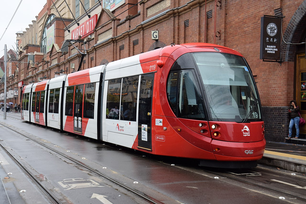
Vehicles would be 33 metre low floor (or 70% low floor) vehicles like the CAF Urbos 3. Overhead power would be used.
A 5 unit CAF Urbos 3.
The Route
The line would start at the Civic Corner (near Te Wai o Horotiu rail station and Aotea Square) and run south to Dominion Road to the Eden Quarter shopping area between Bellwood Avenue and Valley Road.
Route with Stations
The Civic Corner is where the current Dominion Road buses terminate so it would be the same destination for most current riders (except those going to the Universities). Stopping the line here would also avoid the heavily built up northern 800 metres of Queen Street where there will be conflicts with local merchants.
Just South of the Civic Corner Stop
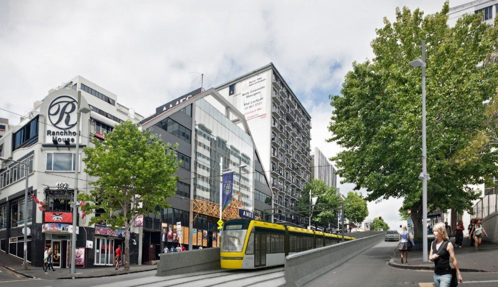
The line would go south across Mayoral Drive and then climb up Queen Street. At some point up the hill it would in into a tunnel under Karangahape Road. There would be a stop near here. This could be on one side of the tunnel or perhaps even inside it.
A train goes through the short tunnel under Karangahape Road
The line would then continue along Upper Queen Street before turning into Ian McKinnon Drive and following it to Dominion Road. Along this section we should future-proof the line for a future branch along New North Road.
Heading up Ian McKinnon Drive
The next stop of the line would be on Dominion Road near View Road. This area is a mix of offices, light industry, apartments and houses and is ripe for increased density.
The rough location of the View Road Stop
The line would then continue south down the hill, across Walters/Valley Road and terminating before it reaches Bellwood Avenue at the Eden Quarter stop. This stop would be placed to allow passengers to easily transfer to and from Dominion Road buses. It is also a short walk to Eden Park.
The location of the Eden Valley stop
At the final stop the driver would walk to the other end of the train for the return journey.
Operation
Making the conservative assumptions that each train averages 15 km/h in the inner city section and 30km/h in the other sections with a wait of 30 seconds at each stop we get the following travel times:
Stop name
Distance from Civic
Average Speed
Travel Time
Civic
0m
n/a
Depart 00:00
Karangahape Road
800m
15 km/h
Arrive 03:15 Depart 03:45
View Road
2600m
30 km/h
Arrive 07:20 Depart 07:50
Eden Quarter
3230m
30 km/h
Arrive 09:00
This would be an average speed of 21km/h which possibly could be increased, especially along the Southern sections where there are fewer conflicts with pedestrians and cars.
Assuming we allocate 2 minutes at each end for turnaround then each vehicle would takes just 22 minutes to completed the whole route. This means that just five vehicles should be able to maintain a headway (interval between trains) of 5 minutes in both directions.
Line Capacity with a train every 5 minutes and using 33m light rail cars carrying 210 people (as in the Auckland light rail proposed) would be 2500 passengers/hour in each direction. This comfortably exceeds what the current double-decker buses carried in peak mornings during 2019.
The line should be designed to allow two cars per train bringing length to 66m. If these were brought in and headway was reduced to three minutes then capacity would be 8400 passengers/hour.
Buses coming towards to the city would drop off passengers at a stop just before Bellwood Avenue. They then turn left down Bellwood Avenue to Eden Park and then return along Walters Road before making a right-hand turn back into Dominion Road and stopping to pick up passengers before heading south.
Route for Dominion Road buses
Currently buses at peak hour take 11 minutes via Queen Street and 18 minutes via Mount Eden Road and Symonds Street, so this would save time for most passengers even with the transfer between bus and light rail.
Service Facility
The line would need a small service facility for vehicle storage and maintenance. This would eventually be replaced when the line is extended but would be needed to serve the initial fleet.
A property would need to be purchased and built. Probably near View Road although there are other options such as public land on Ian McKinnon Drive.
Building it.
Total distance would be just 3.3 kilometres which should be build-able for perhaps $NZ 300m including around seven vehicles. The cost of nearly $100m/kilometre reflects the fairly short line in a built-up area but is actually quite conservative. Costs of similar systems overseas are usually less.
In his original twitter thread Scoot suggested a price of $100m and that a large part of the cost could be covered by a special rate on developments in the area.
Construction should be possible in 3-4 years especially with best practice of working 12+ hours per day. A comparison might be the 5.5km Lund Tramway which was build for ~$NZ 250m in 3.5 years.
Future Extensions
Extensions should be planned as soon as possible to allow a continuous stream of work. I plan to detail these in a later article but they could include:
North along Queen Street to Customs Street. Probably with a stop around Wyndham Street – 750m
North-East from Queen/Customs to Wynyard Quarter. 1-1.5km
South on Dominion Road to State Highway 20 – 4km
South along New North Road and Sandringham Road as far as SH20 – 5km
A replacement maintenance facility will also need to be built. Probably near SH20
Further extensions south of SH20.
Questions
Q: What about the Airport and Mangere?
A: We should not try and serve these areas with the same line as the Dominion and Sandringham Road. Instead a high capacity Light Metro line though Mangere Town Centre, Onehunga, Manukau Road, Newmarket could serve them, See Matthew Beardsworth’s article If we’re going to tunnel light rail, do it right! .
Q: What about going to Britomart?
A: Britomart would be the natural place to terminate the line. However I think there will be strong opposition to any disruption from the local business owners that would delay the project. Building the line only as far North as the Civic Corner avoids the most heavily built-up shopping stretch of Queen Street.
However I think the link to Britomart should be a priority and should be built as soon as possible. Building it later avoids it delaying the initial build of the line.
Q: Won’t this line eventually fill up?
A: The line should handle several times the peak 2019 Dominion Road and Sandringham Road demand. If demand eventually exceeds that then there are options ranging from lengthening the vehicles to building new lines to take demand ( eg along Mount Eden Road). Part of the problem with the government’s current proposal is one line is expected to cover all requirements.
Q: Won’t this reduce car capacity into the CBD?
A: Yes it will. But currently there are only 900 people in 800 cars using Dominion Road during the peak hour (less in Queen Street) . The initial capacity of the Light rail will be 3 times that. Also the line will reduce the numbers of buses going into the CBD.
Q: Would the overhead lines be unsightly?
A; Most of the photographs about include overhead lines. They tend to be fairly inconspicuous. Systems that do away with them cost more and are non-standard.
Q: What about University Students?
A: The line would unfortunately remove direct access to the Universities. Students would have two main options: 1. Get off at the Karangahape Road stop, walk to Symonds Street and catch a bus further down Symonds Street. 2. Get off at Civic Stop and walk up the hill.
With the cancelling of the SkyPath and the short-lived $800 million Pedestrian/Cycling bridge proposal it seems that the only options for the next harbour crossing will be a full scale tunnel or bridge.
However I came across the Youtube video where the author suggests a gondola crossing of Auckland Harbour. I did a bit of investigation myself and looked at some possible routes, the majority of which appear not to work but two might benefit from further investigation.
In the last decade urban gondola systems have become increasingly popular. They work well in difficult terrain such as steep hills, valley or river crossings. They are also relatively cheap which makes them popular in middle-income countries in the Americas.
The Medellin MetroCable in Columbia currently has 6 lines, most of these act as feeders from hill suburbs to Tram or Metro lines.
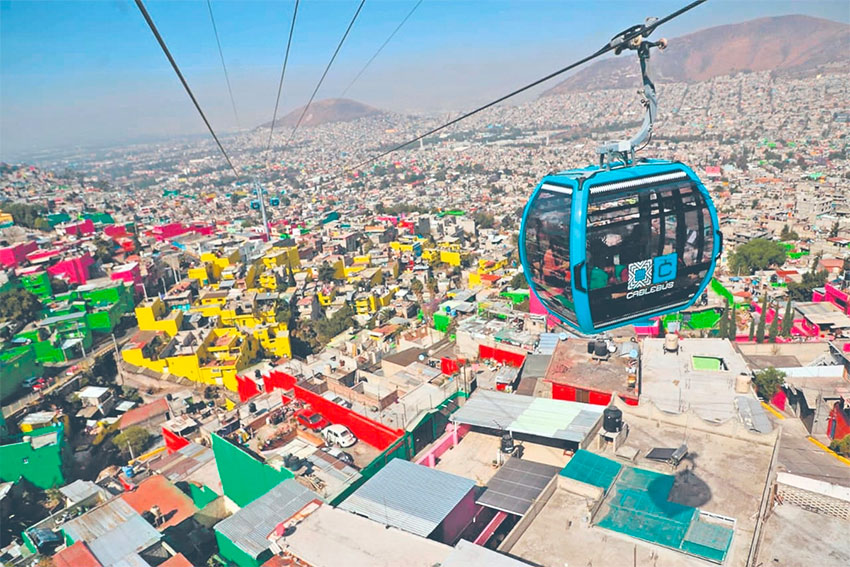
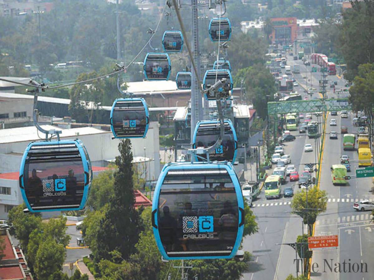
The Cablebús in Mexico City opened two lines in 2021 connecting low income transport-poor suburbs with metro stations.
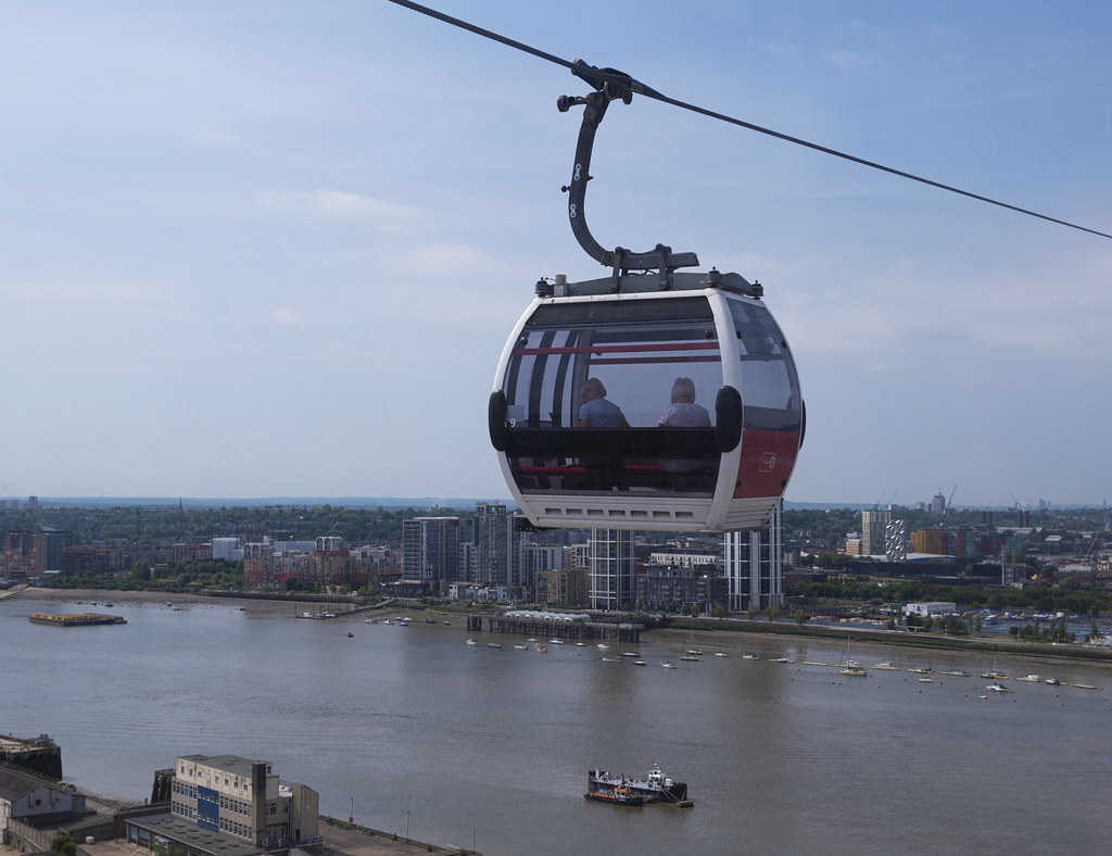
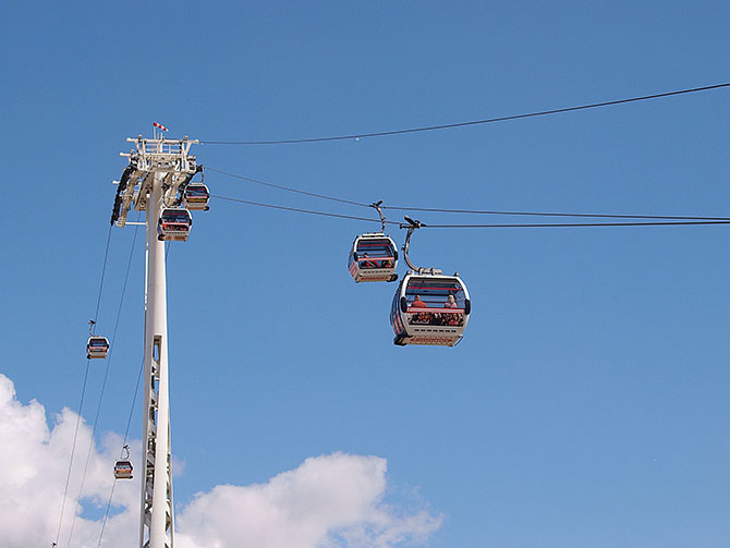
The technology I am assuming is a Detachable Monocable Gondola with cars similar to the Emirates Air-Line in London, Medellin MetroCable and Mexican Cablebús.
Monocable means that there is a single moving cable. Detachable means that each car unhooks from the cable inside stations and moves slowly (or even stops) for easy boarding and unboarding. The general characteristics of these systems are:
8-10 person cars ( able to carry bicycles, wheelchairs etc )
Speed around 20 km/h
Capacity 2500 people/hour in each direction.
Approx 1 car every 15 seconds.
Note that it is possible to increase capacity, for instance the new Medellin line P has a capacity of 4,000 people per hour in each direction.
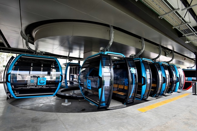
Cars in Station ready for boarding
Options for routes
I have provided details about two possible routes:
Route One is a simple crossing of Auckland Harbour just east of the Auckland Harbour Bridge.
Route Two connects the CBD (near Elliot Street), the University of Auckland and Parnell.
Note that apart from at stations cable systems are along able to make very slight turns at each tower. I have pretty much assumed each line will be straight apart of at stations.
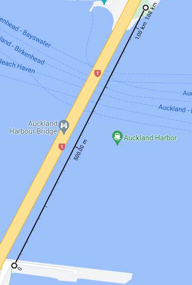
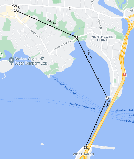
Route One – East of the Bridge.
The will start from a station near the current Ponsonby Cruising Club. A 50m mast 150m north, then a 700m span across the harbour to another 50m mast and then a station in the Stokes Point Reserve.
Total length is 1100m. Travel time around 5 minutes.
This route is a direct replacement of the Skypath. It would cater to cyclists and pedestrians needing to get between Stokes Point and Westhaven. The exact placement of the stations is flexible. The main difficulties are the height required to provide room for tall ships to pass underneath. The Emirates line has similar requirements to allow Thames river traffic and higher than usual towers.
Apart from some sightseers this line would mainly serve cyclists wishing to go directly between North Shore and the city. This Greater Auckland article shows the 2020 Skypath business case was estimating 4500 daily users for the Skypath a few years after it was built.
The high towers and steep climb on the Emirates Air-line
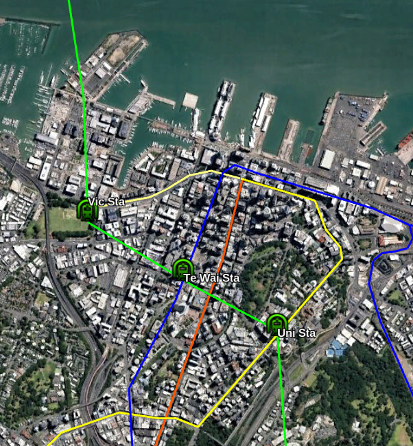
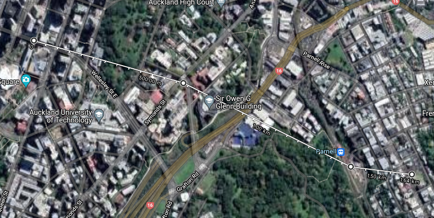
Route Two – Elliot Street to Parnell via Wellesley Street and the University
This would start with a station near the corner of Elliot Street and Wellesley Street West (possibly in front of Bledisloe House). The line would go east above Wellesley Street and over the Art Gallery, Albert Park and parts of the University to a station at the University (perhaps at the corner of Grafton Road and Symonds Street). The line would then go across Grafton Gully to a station at Parnell Train Station and then up the hill to terminate on Parnell Road. The total length is around 1700 metres.
The Elliot Street to Parnell route
There are 4 stations on this route.
Parnell Village (near 236 Parnell Road) is an employment & entertainment area.
Parnell Train Station is near Parnell and the University but down a hill from both and across busy roads from the University. It is within walking distance of the Auckland Museum.
The University is well served by Symonds Street buses but not by rail and is cut off from the CBD and Parnell.
The Elliot Street endpoint would be just 50 metres from both the Aotea Train Station and a proposed Queen Street light rail station near the Civic.
Starting Point and direction of Line to University / Parnell
The idea of this line is to cross the difficult terrain that separates Parnell, Parnell Station, the University and the CBD. There should be a lot of possible journeys between these four. It will expand the effective radius of Aotea Station, Parnell Station and a Civic light-rail station. It would also improve Parnell’s connectivity.
Cablebús line over a busy road
Travel times ( assuming 20km/h speed and 1 minute per station ) on the most likely journeys:
Journey
Walking Distance
Walking time
Cable distance
Gondola time
Elliot St to University
800m
11 min
600m
4 min
Elliot St to Parnell
2100m
30 min
1700m
9 min
Parnell Station to Parnell
400m
6 min
250m
3 min
Parnell Station to University
1400m
20 min
800m
5 min
This line has the potential to be very busy. All the stops on the route would benefit from the improved inter-connectivity.
Two extensions to the line are possible. At the Parnell end the line could be extended down to a station located in the valley around St Georges Bay Road to serve the businesses (and housing) located around there.
Another possible extension of the line would be directly along Wellesley St West from Elliot Street to Victoria Park. I am unsure if traffic to/from the Victoria Park area would justify this however.
Other Routes
I had problems finding other routes that were suitable for gondolas. I’ve included a route to Birkenhead as an example of one that does not appear to be competitive with the existing bus as an example.
The majority of possible routes had various combinations of long distances (which take too long at 20km/h), low density/population at station catchment, already being covered by existing links and lack of obvious demand.
Westhaven to Birkenhead via Northcote Point and Marine Terrace.
This starts on the western side of the Harbour Bridge near a small Park/Bungy HQ. It goes over the harbour alongside the Bridge and has a station near “The Wharf”. The Line would then go across Little Shoal Bay to Little Shoal Bay Reserve. There would be a turning point there to go north-west over the gully of the Le Roys Bush Reserve to a station on the side of Birkenhead Avenue near the viewing platform.
Length 3.9km and end to end travel time of around 15 minutes.
The problem with this line is that Westhaven is not a good destination. Route One across the harbour fills a gap for cyclists but extending the line to Birkenhead doesn’t seem significantly improve the catchment (especially for non-cyclists).
Other possible routes I looked at
A simple crossing West of the Bridge
From the south-east of St Mary’s Bay to Stokes Point
From Wynyard Quarter to Stokes Point.
From St Mary’s Bay to Stokes Point and then the Akoranga Bus station
From Wellesley Street West to Stokes Point.
Between Devonport and the city
Above Lake Road from Devonport to Takapuna
Between Stokes Point and Bayswater
Between Akoranga Bus station and Devonport
Conclusion
Urban Gondolas do not work as a general solution to urban public transport but are suited to certain niche routes across difficult terrain.
Starting from the simple harbour crossing I looked at several cross harbour routes but most were unpromising due to lack of under-served destinations that could be easily connected. I ended up just keeping the basic harbour crossing to fill the gap for cyclists and walkers.
The Elliot Street to Parnell line on the other hand might be a good fit for a gondola. It is less than 2km long but connects 3 popular locations and an under-utilised train station.
Costs of gondolas are fairly low compared to other PT options. The two Cablebús lines in Mexico City are each around 10km long and cost $US 146m and $US 208m. Ballpark estimates might be between $NZ 100 million to $NZ 200 million for each route, hopefully closer to $100m.